case study | environmental |
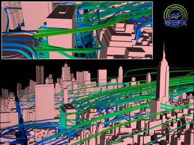
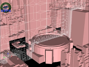
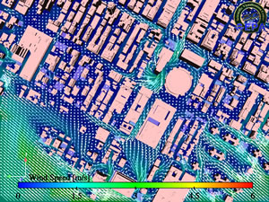
EPA uses Harpoon and EnSight The U. S. Environmental Protection Agency's (EPA) National Exposure. Research Laboratory is working with the US EPA's Scientific Visualization Center on the Urban Microenvironments project. The project simulates human exposure to environmental pollutants in urban microenvironments. Understanding the pathway of air pollutants from its source to human exposure in urban areas has been an ongoing activity for many years, but has recently been dramatically enhanced by new methods using visualization of CFD computations. Computed wind fields are used to estimate and visualize air pollution transport in urban areas. Visualization methods are critical to understanding the complex wind fields. This series of images shows wind fields near Madison Square Garden in New York City. CEI's Harpoon was used to create a 19 million cell mesh for the application, and Fluent, Inc CFD computation was used to simulate the wind field. The calculation was a steady-state average wind field used to provide cell specific wind velocity vectors and calculated velocity streamlines. Visualization was done in EnSight Gold. Images courtesy of project principal investigator Dr. Alan Huber, U.S. EPA National Exposure Research Laboratory, and Dr. Matt Freeman, a contractor with the U.S. EPA's Scientific Visualization Center (managed by Heidi Paulsen).
|
Image
a shows selected velocity streamlines
Image b shows a vertical slice of mesh.
Image c shows a horizontal
slice of the wind field
|